Conduit Management and Digital Twins:
CAD and GIS Working Together
Intelligent infrastructure design works with GIS to model systems for better construction and improved asset management via the use of digital twins.
| Dennis Beck, President/CEO, Spatial Business Systems, Inc.
Introduction
Our earlier blogpost in August 2021 explained how digital twins can be used to more effectively manage critical, networked utility infrastructure. That post introduced the concepts of digital twins and the digital thread. This follow-on post focuses on a more specific example of underground conduit management and how a robust digital twin model can support the needs of design, construction, and asset management. Historically, the information generated during the design process has not been directly usable for related business applications such as GIS and inventory management. The advent of intelligent design solutions and their ability to create robust, re-usable digital twins provides a means to address the challenges of critical infrastructure data management.
Conduit Management: Challenges and Opportunities
Digital twins are often thought of as unique, distinct objects, and while that can be the case, they provide much greater value when working as groups of twins within connected systems. Electric and telecommunications conduit networks can be considered a system of digital twins. Management of these conduit networks can get quite complex and is and critical to support proper network operations. We believe this is a particularly important topic as management of underground networks in urban areas is becoming more challenging to model due to higher density and complexity in very tight, confined locations. These assets need to support electric distribution and telecommunications while coexisting with gas, water, district heating, and other networks. Though distinctly different, these networks are also linked via common construction operations. For example, joint trenches impact shared construction costs and other joint business workflows such as operations and maintenance.
Fortunately, advances in both GIS and CAD technologies are creating a convergence that provides a path for addressing these business challenges. In the field of GIS, the market leader Esri has introduced key data model elements and programming interfaces that support conduit management in their ArcGIS Utility Network product. This includes a capability referred to as non-spatial objects that can be configured to represent complexity of conduit networks (i.e., ducts’ location and relationships) while maintaining scalability of GIS and performance of the network analysis (I.e., capacity planning). Meanwhile, intelligent CAD solutions, such as Automated Utility Design™ (AUD) from SBS, can provide full support for design and editing of conduit networks in 3D. For example, a designer in AUD can select a duct feature in the 3D view and “move it” to a desired free port of a vault’s digital twin, eliminating the need for legacy types of 2D representations such as knockout features and draft schematic views in a digital twin design. Most of the required diagrams and schematics views can be auto generated from the digital twins in design and shared with other systems or printed on construction sheets (for paper-based workflows).
Also, designing in 3D is a critical capability for a correct engineering of conduit networks and constructability analysis. As an extension to AutoCAD, the AUD product creates a model-based design, which is based on unique digital twins that support not only the design and construction business processes but provide a foundation for downstream applications such as GIS and Enterprise Asset Management. The bi-directional integration of these technologies forms a basis for solving the conduit management problem.
Intelligent Design of Conduit Systems
Traditional design of networked utility infrastructure has typically involved rather simple 2D layouts, referencing conductors, conduits, and associated paths between equipment and consumers. While this has served the industry for many years, building a well-defined digital twin during the design phase ensures not only a properly engineered system but also provides a framework for related business needs. A sample model is shown in the figure below.
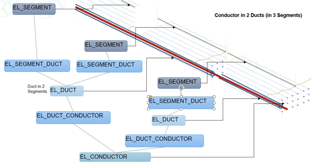
While this model may appear to be quite abstract, it forms a basis for shielding an engineer or CAD designer from having to understand the details of the underlying digital components that turn points, lines, and areas into intelligent features that represent networked infrastructure. This provides a very powerful tool that allows a designer to build a digital twin without having to understand the complexities of network asset modeling.
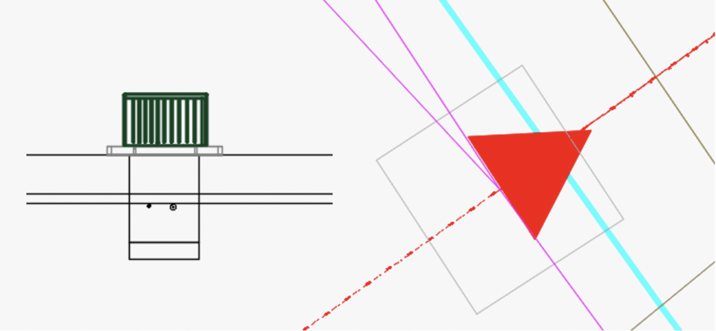
What the designer sees is something quite different. This abstract model can be portrayed as a 2D layout that supports typical construction drawings. These drawings contain the necessary information to enable the construction process, including trench widths, offsets, fill, and depths.
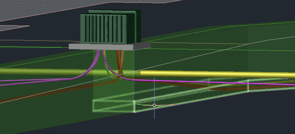
Another advantage of intelligent, model-based design is the ability to model the 3D elements of the design in the background while performing a 2D layout using standard CAD tools. This enables essential design and engineering capabilities, such as clearance checking, constructability, safety, and compliance with standards, reducing the risk of construction-related issues when the design moves to the field. Bill of materials can also be generated much more accurately as lengths can be properly calculated based on having a 3D representation of the conduit path. The addition of 3D, digital-twin based models also provides for the benefit of highly visual design checks. A 3D view of the design above is shown in the connecting diagram.

Here, another example is shown. In this case, the real-world model shows how the conductors pass through rotated vaults while including proper elevations and the necessary duct details.
GIS, CAD, and Conduit Management
While CAD-based intelligent design functions create models to support safe and effective construction of infrastructure assets, GIS plays a key role in data management, analysis, and lifecycle asset management of those same infrastructure assets. The design process often involves highly detailed representations of the planned infrastructure, usually over a fairly finite work location. On the other hand, the GIS manages a very large amount of assets, typically over a large geographic area. The same assets are represented in each system; however, their usage and purposes are distinctly different. For example, design typically requires highly accurate, real-world locations while conduit represented in GIS is often offset to ensure proper visualization on a two-dimensional map.
Examples of GIS-based conduit management activities include visualization of joint trenches, duct banks, and vaults and operations support for performing inspections and replacement activities. Planning and revenue related functions such as capacity planning, shared resource management, and replacement analysis are enabled by having well-defined conduit systems within the GIS. Similarly, fiber management functions for telecommunications rely on the GIS representations to manage visualization of fibers, cores, and cables and to provide a visual way of managing fiber splices.
What’s Next: Digital Twins and Next-Generation Networks
The business applications described above offer tremendous value for traditional utility and telecommunications assets. But the future of the electric grid is demanding a better way of managing advanced, dynamic networks. Distributed energy resources, the proliferation of sensors, advanced devices, and prosumers are driving the need to deliver advanced network models based on digital twins. It’s no longer practical to have large teams of manual data entry personnel editing different systems to support multiple network-based business applications.
Digital twins, based on intelligent design, integrated with GIS and other network-based systems provide the opportunity to enter data in one location and share it throughout the asset lifecycle without having to deal with redrawing, duplicate data entry, and the inevitable risks associated with out-of-date information.
If you have any questions, please contact SBS at [email protected]. We welcome the opportunity to share more details regarding the integration of intelligent design solutions and geographic information systems along with your digital twin and design integration requirements.