Category: SBS Blog

  • Integrated Utility Design Workflows Leverage the Best of GIS and CAD

    Integrated Utility Design Workflows Leverage the Best of GIS and CAD

    In the 1990s, most organizations developed monolithic platforms that embedded engineering design in their geographic information systems (GIS). While the concept of going to those common “suites” made sense at the time, it failed to address the needs of the GIS-mapping technicians and computer-aided design (CAD)-based engineering designers.

    Interestingly, despite the fact that utility designers and spatial analysts have been debating for at least a decade against design frameworks embedded with GIS, many organizations continue to use them.

    The legacy systems have had a fundamental set of issues since they were originally conceived:

    • They don’t support the different graphic standards required for design and GIS.
    • They’re not sufficiently accurate.
    • They don’t have the necessary information to support thorough engineering-design work.
    • They’re highly customized and extremely difficult (and costly) to upgrade

    The advent of GIS as a platform has opened the door for utility organizations to transform their use of legacy-engineering design systems embedded in GIS into integrated utility workflows that addresses the above issues.

    GIS becomes a platform

    Skye Perry recently contributed an article to T&D World, “The Future of GIS – The System Becomes a Platform” that explains a fundamental change going on in the GIS world.

    He explains how GIS is becoming less specialized, allowing utility organizations to use it in new and powerful ways. For example, Perry notes that GIS will soon be accessible from any device and from anywhere, using data from GIS servers.

    That marks a drastic change in the system, which not long ago was accessible only from desktops through products such as Esri’s ArcCatalog and ArcMap. The ability to gain access to GIS remotely can fundamentally change the way utility organizations build systems and best-of-breed products.

    As a result, utility organizations that attempt to use GIS for engineering design applications no longer need to avoid using the best tools to accomplish their work. By focusing on integrated utility workflows instead, they can drastically improve their efficiency.

    Advantages of CAD within an integrated utility workflow

    The most prominent challenge with using GIS as a primary engineering design tool is that it’s simply not as accurate or useful as performing designs in a CAD-based tool. GIS is fundamentally used to support operations by providing safe, legible maps.

    On the other hand, CAD-based design is required to provide highly accurate instructions to support the construction process. In more than one case, inaccurate designs have created serious problems, and in some cases even safety issues.

    Historically, all the rich data and powerful analysis available in GIS has not been tapped to generate better designs and workflows when working from within CAD. The question to ask is: If you’re using GIS as a primary engineering design tool for utility systems, but still have to use a spatial analyst to counteract the inaccuracies of GIS features, is it helping you? The answer is often “no.”

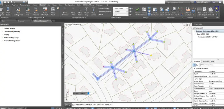
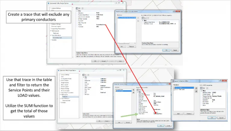
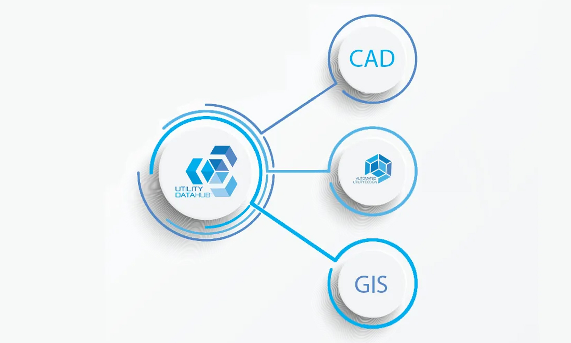
    Automated Utility Design™ (AUD), from SBS, is a model-based design software that uses the power of AutoCAD®Map3D to take information from sources such as Work and Asset Management, CAD-based design files from engineers and developers, and GIS to automate the design of utility systems and integrate design workflows accurately.

    SBS has an advanced suite of integration modules, Utility DataHub™, that allow organizations to get the most out of GIS while reducing the time it takes to design and construct systems. Here are just a few benefits organizations can expect when integrating software such as AUD into their utility workflow:

    • Improved design quality
    • Improved designer productivity
    • Reduced costs in training and change management
    • Better information to support operations and business analytics
    • More-timely access to important data and information

    If you’re interested in streamlining your utility design workflows, SBS has an annual conference, the Peer Utility Group (PUG), that highlights the successful approaches that have been taken by utilities, large and small, to streamline their workflows with AUD and Utility DataHub™. Interested parties are invited to attend the next PUG meeting at Puget Sound Energy in Bellevue Wash., August 26-29, 2019.

    If you can’t make it, you can learn more about how we can help you revolutionize your utility workflows by visiting our website.

  • SBS Joins the Esri Partner Network

    SBS Joins the Esri Partner Network

    Esri – Autodesk Strategic Partnership Ushers in a New Generation of Integrated Design Solutions

    SBS is pleased to announce its acceptance into the Esri Partner Network.  And it’s quite an exciting time for SBS and our clients.

    SBS sees tremendous value of being in the unique position as one of the first Autodesk solution providers to now be part of Esri’s strong community of partners. SBS has a rich heritage in geospatial solutions ever since we founded the company back in 2002.  As the company has grown, SBS has made a concerted effort to focus on productizing the technically demanding needs of integrating GIS and CAD information with both engineering systems and traditional information technology platforms as offered by companies like SAP, IBM, Oracle and others.

    Why did SBS became an Esri Partner?

    As an integrator, SBS has worked with most of the geospatial technologies and enterprise systems that support utility design workflows.  As our work has progressed, it has become quite clear that a great majority of our utility customers are utilizing Esri as a foundational platform for their geospatial needs.  Last year alone SBS worked with over 30 different utilities that use Esri GIS products and we are on track to work with even more in 2019.  SBS has made significant investments to develop world-class Esri technical skills and continue to expand our offerings as they relate to Esri-based integration and value-added applications.

    The fact that Autodesk and Esri have agreed to a collaborative relationship has also had a big impact on the direction of the industry.  SBS will continue to advance its offerings as these two market leaders work together to improve data sharing and user experience.  You can learn more about the Esri-Autodesk partnership and what it means in this SBS blog post.

    What Does SBS Have to Offer the Esri User Community? 

    Over the last several years we have developed some very exciting capabilities that leverage the Esri platform from within our products.  Here is what we have been doing:

    Integrated Design Solutions

    SBS’ flagship product, Automated Utility Design™ (AUD), is now seamlessly integrated with ArcGIS and the Utility Network.  AUD and our Utility DataHub™ integration platform fully support ArcGIS Platform Identity.  AUD designers are now configured as users in ArcGIS Enterprise with assigned Esri user types.  Esri data sources are directly available within the AUD platform to support engineering design for electric, gas, water, telecoms and other utilities.

    Esri’s Utility Network is now dynamically integrated with AUD to provide advanced network analysis and geospatial insights to support utility engineering design workflows.  For example, CAD-based designers can now query the ArcGIS Utility Network to collect load information and assess customer impacts.  This also positions Esri and SBS to support more advanced design constructs as our utility clients deal with the impact of Smart Grid on their physical networks.

    Intelligent Mobile Workflows

    Esri mobile solutions can now fully take advantage of utility designs to support field data collection, verification and inspection workflows.  Many of our distribution design software users rely heavily on mobile GIS applications to perform up front field verification activities to support designs.  This flow of information is now seamless and truly streamlines workflows while also enabling a much higher level of design quality.  On the back end of the design process, SBS supports as-built mobile GIS workflows along with common BIM (building information management) capabilities.

    3D Substation Infrastructure Data Sharing

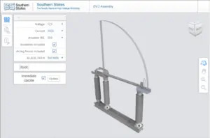
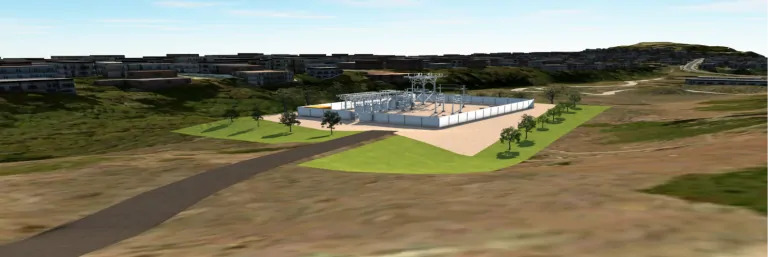
    SBS is also in the early stages of working out data exchange protocols and workflows for sharing data between the SBS Substation Design Suite™ and ArcGIS Professional and ArcGIS for Buildings.  We are also evaluating the potential transformation of this data into the Esri Utility Network model.   Recently we have included Esri-based geographic information within Autodesk’s BIM 360 to provide a geographic context to support construction and asset management of substations.

    Come See Us at the Esri User Conference, Booth #208!

    We are committed to helping our clients get more value out of their investments in CAD and GIS technologies via innovative applications and configurable, cost-effective integration solutions.   Please come by and see us at this year’s Esri User Conference in San Diego, July 8- 11.  We’ll be at booth #208 and look forward to seeing you.

  • Esri User Conference 2019

    Esri User Conference 2019

    Visit SBS at booth #208 at the Esri User Conference, July 8-12 in San Diego. As one of Esri’s newest partners, SBS is excited to show our Automated Utility Design™ (AUD) product seamlessly integrated with ArcGIS and the Esri Utility Network Model.

  • Southern States and Reliaguard add content to Utility Content for Substation Design Suite™

    Southern States and Reliaguard add content to Utility Content for Substation Design Suite™

    Manufacturers 3D models continue to grow with the addition of content from Southern States and Reliaguard.

    June 14, 2019

    SBS announced during the Substation Design Solution Industry Consortium (SDSIC) 2019 Spring Meeting that Southern States and Reliaguard will be adding content to SBS’s Utility Content service for Substation Design Suite.

    Southern States EV-2 Assembly Configurator

    Southern States, the largest switch manufacturer of high voltage disconnect switches in the world has developed their EV-2 Assembly into a configurable model inside the Utility Content Configurator. The Southern States configurator was the result of a three month collaboration with SBS and Southern States teams on development and testing.

    Tom Speas, VP of Corporate Marketing for Southern States joined Jack Hopson, SDS Product Manager for SBS on the joint announcement during the SDS product update at the SDSIC. Tom Speas went on to talk about Southern States commitment to the development of 3D models for it’s products. “Work is already underway on center break and double end break switches. In addition, we are planning how best to offer switch attachments and provide usable op-mech configurations that can be integrated with the individual pole designs for each switch type.”

    Reliaguard provides a superior portfolio of wildlife mitigation products. Reliaguard continues to work with the SBS team and expects to have their stock content loaded into Utility Content sometime during the 2019 calendar year.

  • 2019 Peer Utility Group Conference

    2019 Peer Utility Group Conference

    6th Annual PUG Conference hosted by Puget Sound Energy

    We are excited to announce this year’s conference will be held August 27th – 29th, 2019 and will be hosted by Puget Sound Energy, Bellevue, Washington. We are busy planning all of the details and will make updates as they become available. To view the details of the conference and to register please visit this year’s conference page. As we make more plans and finalize others we will be making updates to this site.


    If you have any questions or requests please feel free to reach out to us.


  • 2019 Milsoft User’s Conference

    2019 Milsoft User’s Conference

    Join SBS at the 2019 Milsoft User’s Conference, June 11-13. The event will be held at the Omni Orlando Resource at Championsgate in Orlando Florida. Meet the SBS team, at booth 34, and see how SBS distribution design and integration solutions help utilities share information and streamline their utility workflows.

  • Automated Utility Design™ 8.0 Now Available

    Automated Utility Design™ 8.0 Now Available

    New Version Improves Performance, Adds Smart Trace and Supports Esri Utility Network Model  

    Automated Utility Design™ Version 8.0 (AUD) is now available!  AUD 8.0 is the biggest release todate from SBS and adds several significant enhancements to the product.  Most notable  are the extended capabilities to support integration with Esri’s ArcGIS Pro and the new Utility Network (UN) Management extension which was announced during our January 2019 blog post While these new features were designed to support Esri Utility Network, the capabilities will improve data exchange between most advanced GIS systems including G/Tech and Smallworld.  While the previous post highlighted AUD’s advanced modeling capabilities and improved editing features, this post will focus on some of the key new AUD capabilities.  

    Improved Performance 

    continual objective of SBS is to improve overall user experience and product performance  AUD 8.0 continues that standard  

    As utilities are putting more assets underground, SBS teamed with our customers to investigate how to improve performance for complex underground design scenarios. The results of this analysis led to a 15% or greater increase in performance for underground design.  Examples of enhancements include faster editing of conduit positioning in the trench layout, 3visualizations for the trench and a 2D cross-section of the trench.  

    Additional changes in AUD 8.0 resulted in a 25% decrease in the time required to open larger drawings as well as dramatic improvements to responsiveness when selecting and editing with AUD Info tools on larger, complex designs. 

    Additionallyimprovements have been made to support Customer’s that have very large material catalogs.   While most customers will see a slight improvement in performance, a comparative test of one customer with a very large catalog showed nearly 5-fold performance improvement.   

    Improved User Interaction 

    AUD 8.0 expanded trace capability, combined with the Utility DataHub’s ability to remotely invoke GIS transactions, provides the Designer a with a more complete systemlevel design and analysis solution. Previous versions of AUD provided basic highlighting to show what features had connectivity in the design.  AUD 8.0 now provides configurable trace definitions to select parts of the network.  Working in tandem with the new AUD Table functionality, an AUD user can now perform traces that will automate routine counts and calculations of features in a design.    

    Prior to AUD 8.0, tracing was limited to highlighting the features that had connectivity.   Although the connectivity tracing capability is extremely useful for design integrity to ensure connectivity of features, it was limited in the ability to support system level design integrity and analysis.  


    AUD showing Connectivity 


    Through simple configuration of AUD options, enhanced tracing can be added to an AUD template.  In the sample below, an intelligent trace was created to read the load of each new service point designed along this circuit The results are displayed in a table showing each individual service point’s load, as well as the total load being added.  To simplify this common search, the analysis pallet was configured with a new button to initiate the trace on command.            


    The new trace capability, combined with the power of the SBS Utility DataHub Design-GIS module’s ability to interact with the GIS, advances the integration of CAD based engineering design with GIS spatial analysis.   

    Better Data Exchange  

    SBS has been working collaboratively with our user community to further improve CAD mapping and conversion workflows for external parties that need to share data with AUD.  A new command can be used to easily perform bulk conversion of non-AUD CAD drawing objects. The conversion is based on matching AUD Styles as well as optional new value mappings in the Style definitions.  These enhancements are particularly helpful for utility organizations that need to receive traditional CAD data from Applicant Designers or third-party engineering firms. 

    The better exchange of data reduces the need for 3rd party conversion tools, manual redrawing and data clean-up while simplifying the overall workflow.  It also allows utility organizations to have more current and accurate data available for their GIS and critical downstream systems such as engineering analysis, outage management, advanced distribution management systems.   


    ***** 


    AUD 8.0 continues the SBS tradition of working collaboratively with our user community to advance the state-of-the-art in utility design solutions.  We particularly appreciate the customers in our SBS Peer Utility Group that contributed their ideas on how to improve AUD.  We welcome future feedback from all AUD users and encourage you to join the Peer Utility Group as a forum to share your thoughts and ideas.   

     For additional information on Automated Utility Design please contact Stefen Dobrec[email protected].    


  • SBS Releases Substation Design Suite™ (SDS) Physical and Protection & Control 7.4

    SBS Releases Substation Design Suite™ (SDS) Physical and Protection & Control 7.4

    Substation Design Suite™ 7.4 brings new features and bug fixes for improved functionality.

    New Features

    SDS — Physical features:

    • SDS will now alert you to using read-only files.
    • When selecting cylindrical surfaces for Round Bus, it will obey bus offsets.
    • Angle Bus will now use overhang parameter.

    SDS — Protection & Control features:

    • New “No fan-in” mode to link fanned-in wires back to a stand-alone cable label.
    • Option to add schematic wire layer-specific suffixes to wiring diagram annotation.
    • SHOW WIRES tool for QA’ing elementary/schematic wiring issues.
    • Additional options for DREF cross-reference attribute.
    • New SWAP TERM BLK tool for multiple, in-place schematic H/V swaps.
    • Enhanced TOGGLE SYM tool to also do the above.
    • Multiple data display options for SDS smart tables and for the rollover tool.
    • Easy link added to wire sizing and voltage drop calculator.
    • New support for cable schedule and physical workpoint data set.
    • New command to associate rev cloud or MTEXT or TEXT to a given work-order.

    Bug Fixes

    SDS — Physical includes: 

    • Bus Offset Tool will offset based on pick sequences.
    • Creating a constraint after creating a ground grid sketch will no longer crash if “Edit Sketch” remains open.
    • Deleting paired cable will no longer show an error.
    • AutoRoute Path on simple straight lines no longer generates an error message.
    • Bill of Material type will now let you select the Parts Only option.
    • Fix to Below Grade Cable to create single .ipt file during creating and editing cable.
    • Start and end points are now in the correct order when placing a “right L” piece of trench.
    • Able to read current and previous LandXML file formats.
    • Inventor will no longer crash when selecting an angle bracket for running a flat lead from surface to surface.
    • Adding ground grid run to an existing grid will now place correctly.
    • Fixed multiple errors related to conduit operation.
    • Lightning Protection fixes:
    • Add Shield Wire with two points will now adhere to the SDS Content Editor materials.
    • Part number, description and materials from SD Content Editor are now applied to newly created parts.
    • Material is now adjusted when using Edit Shield Wiring.
    • Shield wire update now updates connection location if changed.
    • BOM will now report wire length.

    SDS — Protection & Control includes:

    • Wild-Card Find/Replace – Project-wide find/replace of RJT attributes on other than active dwg now cleanly maintains displayed location.
    • SDS_DREF will now update summary messaging at end of command run.
    • Changed operation of Change Status for ‘Remove’ when using SDS_EDIT-WIREMODS. This now erases these marked entities instead of moving them to the ‘As-Built’ layer.
    • SDS_WIREMODS will now extract non-blank MFG/CAT/ASSYCODE values into work-order add list report.
    • SDS_SCOOT will now work in AutoCAD Electrical 2018 and above.
    • Fixed an issue with the SDS_ANNOFAN tool that alerts you to a “spares count” too low if using Schematic Cable Fan-In tool. The fan-in symbol will no longer look like a cable marker and add conductors to used count.
    • When using the SDS_ANNO command, little leaders will now insert annotation on very large wiring diagram symbols where the attribute name suffix hits “L#” or “R#” where # = digit.
    • SDS_REFONLY, WIRE SEQUENCE – Marking REFONLY will no longer blank out any wiring sequence assignment held on the picked black instance.

  • Announcing Automated Utility Design™ 8.0

    Announcing Automated Utility Design™ 8.0

    Premier Utility Design Tool Supports Esri’s Utility Network Model

    SBS has delivered a steady stream of enhancements to Automated Utility Design™ (AUD) since we first released the product back in 2016. We are quite excited to announce the trend will continue with the upcoming release of AUD Version 8.0.  AUD 8 and the corresponding release of SBS Utility Datahub™ integration suite extends support for advanced integration with Esri’s ArcGIS Professional and the new Utility Network (UN) Management extension. (more…)

  • ModelMap Configurator

    ModelMap Configurator

    Based on Customer feedback at the 2018 Peer Utility Group (PUG) conference, SBS has released an update to Utility DataHub™ Design – GIS module. UDH Design – GIS module provides bi-directional data integration between GIS systems and Automated Utility Design™ (AUD). UDH Design now includes the ModelMap Configurator, a user-friendly interface to create, manage and visualize the UDH Design – GIS configuration files that facilitate the transformation of data between the two systems. (more…)