Meet with other energy professionals to experience new technologies available in the industry. Visit the exhibit floor to check out our newest product Substation Design Suite™ – Physical for AutoCAD®. SBS will be hosting Booth #8550. Register today to receive an early bird discount.
Immerse yourself in the conference by attending workshops, super sessions, panel discussions, tours, and exhibits to learn how to power the energy demands of the future. We hope to see you there!
Title: IEEE PES T&D Conference & Exposition
Date: April 25 – 28, 2022
Location: Ernest N. Morial Convention Center, New Orleans, Louisiana
Details:
Register here. Early bird discount deadline is March 27, 2022.
Achieving effective design of utility infrastructure has always had its challenges. Distribution system design engineers need to make thousands of modifications to their networks every year. The projects can range from simple network extensions to major capital expansions. Traditionally, these designs have been done in whatever tool is convenient or available, ranging from simple pencil sketches to highly customized tools that are built into other systems, such as a GIS. Actual engineering of designs has historically been limited, but no matter what system is used, the primary challenges are typically related to a lack of integration. Systems involved with utility design can include CAD, GIS, spreadsheets, specialty engineering applications, work order management systems, financial systems, materials management, and scheduling. If you add a mobile component to the front and back end of the process, a large utility can easily have a dozen or more disparate applications involved when creating and executing utility designs.
Fortunately, the latest advances in CAD, GIS, and enterprise integration are enabling a new generation of integrated, intelligent design tools. This post is the first of a three-part series on intelligent design solutions for utilities. This first article explains what is included in an intelligent design solution. The next two articles will highlight business justification and implementation of intelligent design for utility infrastructure.
What Is Intelligent Design for Utilities?
There are three things that make a utility design solution intelligent:
Ability to be “model-based”
Support for integrated engineering and standards
Support for enterprise integration
Model-Based Design
Model-based design refers to the ability to create intelligent, real-world models of the elements that are being designed. The technical basis originates from the software engineering concept of object-orientation and has been extended to CAD and GIS over the past many years. A properly defined model also serves as a digital twin, which is a digital representation of the infrastructure elements. What this means to a utility designer, in a practical sense, is quite important.
In model-based design, elements are no longer just points, lines, and polygons on a drawing. A line, for example, can be a 3D representation of a conductor or a pipe. It has properties to support engineering and materials management. Network topology is modeled to support important business functions such as network trace, which allows the design application to support network analysis or planning for customers that are impacted by loss of service during a construction operation.
Model-based design enables integration. The modeled objects, in addition to their unique properties, have unique identifiers that can be related to the enterprise systems responsible for all aspects of asset life cycle performance. This can range from finance and accounting to engineering, construction, and operations. These properties enable the sharing of these digital twins across all the necessary systems that are involved with creation and fulfillment of the design.
Integrated Engineering and Standards
Once the model is in place, it is possible to combine physical characteristics along with engineering properties and organizational standards to provide a properly engineered design. The role of engineering in distribution network design has been somewhat limited over the years. This has been driven in part by a desire to quickly generate design documents. Unfortunately, this has had negative consequences in the overall effectiveness of network design and related applications that benefit from higher-quality, well-documented designs. The industry acknowledges that there is a new need to raise the standard of engineering in distribution systems. Electric networks are being greatly impacted by smart grid devices, distributed energy resources, and new demand profiles. Gas distribution networks need to properly engineer and document their networks to support regulatory requirements for safety and system integrity management. All these changes require better engineering.
Integrated engineering can occur within the design tool, or in some cases, it might require integration with specialty external programs to perform an appropriate analysis. Internal calculations may include analyzing localized voltage drop or computing pulling tension for underground cable installation. External analysis is often used when performing more advanced functions such as a non-linear structural analysis of poles or the design of a ground grid in a substation. A system with a well-defined model and integrated calculations can readily support most types of analysis. The more common analyses involved in integrated electric distribution engineering include voltage drop, flicker analysis, bending moment, guying design, and underground cable pulling tension.
Enterprise Integration
Utility designs have historically been created in standalone systems. The finished designs are oftentimes printed out and then placed into job folders for work execution. Along the way, the bill of materials is created, data is entered either manually or in a semi-automated manner, and an estimate is performed. Upon completion of the work, the design is redrawn, sometimes several times, into different systems. Not only is this inefficient, but it also takes a lot of time and causes critical systems to become consistently out-of-date. Having an intelligent model of the design eliminates most of these manual steps and replaces them with an automated, timely workflow.
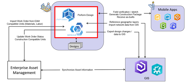
Service-based architectures that work with a data integration hub can provide the necessary integrations to key enterprise systems in a straightforward and configurable manner. Compatible units can be shared from the asset management system; estimates can be derived from an automated bill of material, and the GIS can be kept up to date with the current design information based on preferred workflows. Mobile computing can be integrated at the front end of the design process to support field verification and field construction, and mobile as-built design verification can be performed during the construction cycle. Intelligent design tools facilitate these critical utility workflow integrations with very real opportunities for process improvement.
The example below shows a workflow integration based on SBS Utility DataHub™ and Automated Utility Design™ products:
Why Should I Care about Intelligent Design Solutions?
The benefits of intelligent design solutions are starting to become quite clear based on what we have been learning from members of our Peer Utility Group (PUG). In Part 2 – Justifying Your Intelligent Design Solution, we will review customer experiences that have been shared at PUG meetings. The article will also highlight details about mitigated risks and actual benefits:
Better engineered designs
Improved safety
Reduced liability
Design and construction productivity improvement
Better information management to support advancements in utility networks
SBS Automated Utility Design™ supports flexible and efficient renewable energy system design and construction for Atwell LLC.
Dennis Beck, President/CEO
Last year we shared a blog post on how Atwell LLC uses our Automated Utility Design (AUD) product solution to design wind farm collector systems. The post was based on a presentation the Atwell team shared with our Peer Utility Group user conference in 2019 about projects they were delivering in Missouri and Illinois. This past Thanksgiving, as I was driving with my family through Missouri on my way back to Colorado, I noticed a tremendous number of wind turbines dotting the landscape, and it made me want to learn what has happened over the last 18 months.
I reached out to Jesse Zellmer and Joe Snodgrass of Atwell LLC and was pleased to learn they have extensively grown their renewable practice over the last two years and have now used AUD to design renewable projects in ten states across the United States. This post shares information about a number of new things they have been able to do with AUD across multiple areas of their design workflows.
First, the Atwell team expanded their intelligent design work to support solar systems in addition to the initial projects they have done with wind farms.
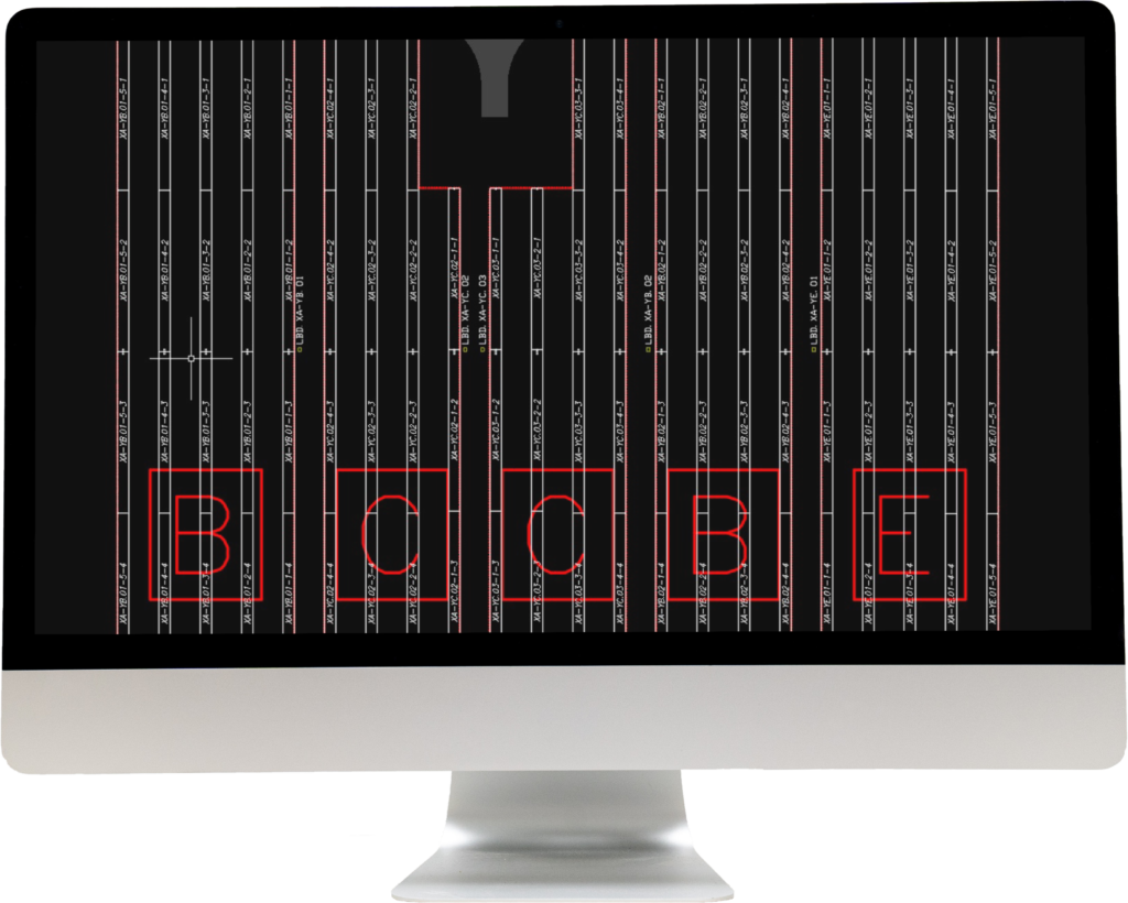
Solar systems, like wind farms, need to optimize their collector systems. Many variables go into creating the best design such as geographic constraints, including terrain, road crossings, and property rights, as well as the numerous factors that impact engineering performance. The screenshot above shows a solar farm that was laid out using AUD. The geographic constraints in the background map and the configured validation rules for generator racking and combiner names are visible, helping with that optimization in design.
Next, Atwell found the intelligent models created in AUD also provide tremendous automation capabilities as the systems go through design changes. A project in South Dakota was initially designed with four feeders. However, plans evolved to evaluate an alternate, more efficient design that only had three feeders. The design changes were quickly implemented in less than a day. From there it was possible to generate a bill of materials and cost estimates that allowed the team to evaluate and ultimately design a better system that would ensure a profitable project. This example shows the modeling power of AUD being leveraged to make a design change process more efficient.
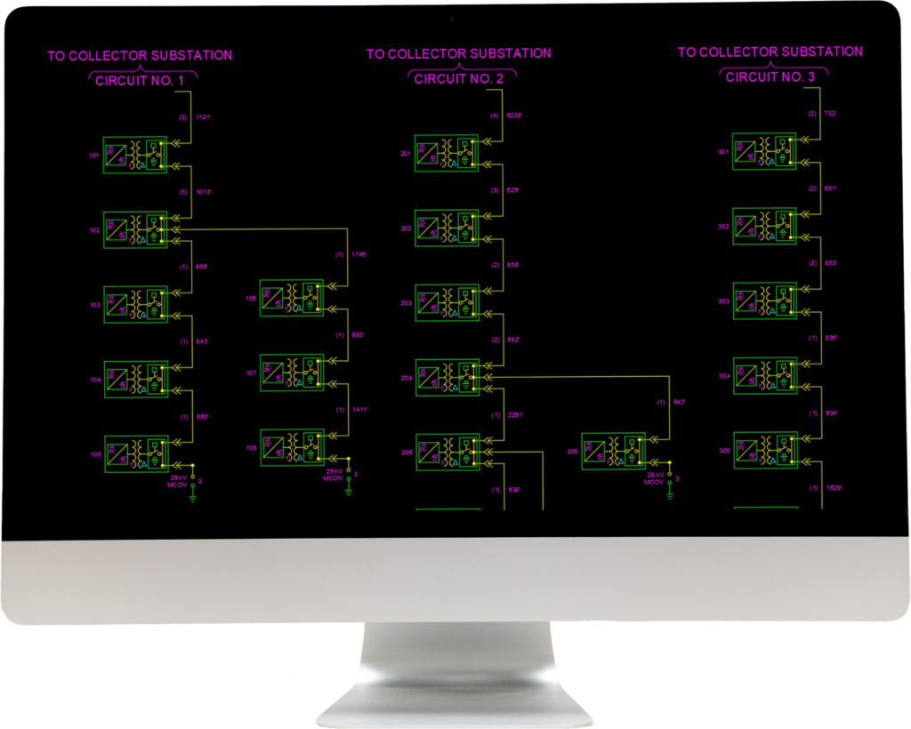
One of the advanced features more recently added to AUD is the ability to auto-generate electrical one-line diagrams. The dynamic nature of the AUD blocks, directly linking the text (cable size, length, and name of inverter station) to feature attributes in the AUD model, ensures that the one-line always agrees with the layout design. The Atwell team has leveraged these capabilities to automate this process in the creation of their electrical diagrams. The screenshot above shows AUD being used to make the post-design/construction print process more efficient.
This leads directly to AUD being able to support simple, powerful, and structured ways of providing highly accurate information to the construction phase of a project. The use of BIM (Building Information Modeling) has been commonplace in the construction of buildings for many years, but it is still in its early stages for infrastructure design.
That’s now changing in the world of renewable energy. We see increased needs for accurate depictions of assets, sequenced in a way that supports an efficient set of construction processes. This includes detailed schedules of equipment and sequential positioning of devices throughout the collection system.
Because these systems change frequently during the design phase, it was common to spend many days doing clean up and manual reviews of drawings to ensure error-free, accurate construction documentation. AUD’s robust modeling capabilities provide detailed, intelligent representations of these objects to ensure that the relevant intelligent design data can be leveraged in support of a changing design process. These BIM-enabling capabilities provide the most accurate and complete information to the construction crews that are installing these systems, all done in a highly automated manner.
Finally, the Atwell team identified the ability to be flexible as one of the key benefits of designing with AUD. Renewable energy projects are subject to ongoing changes that can introduce risks that may impact the overall profitability of a project. With AUD the systems can be optimized, expanded, changed, and re-purposed to provide project investors with the best possible return, while the intelligence and modeling capabilities support internal processes of design, change/approval, and construction.
We hope you are as excited as we are about using AUD to provide innovative solutions to help us more wisely use our earth’s energy resources. Please reach out to us with your comments and questions. We enjoy hearing from you.
Join Steve Kaufman from SBS for a webinar on Wednesday, February 2, to learn different methods for above grade and below grade conduits in SDS Physical for Inventor.
The discussion will include information about UtilityContent.com, WorkPoint cable and conduit path tools, bus browse end fitting, flex conduit runs, patterns, phantom assemblies, and more.
Title: Substation Design Suite Physical for Inventor Above Grade and Below Grade Conduit
Date: Wednesday, February 2, 2022, at 12:00 PM EST
Details: Visit https://www.spatialbiz.com/substation-design-suite/ for more information about Substation Design Suite products. Access the content on the Spatial Business Systems YouTube channel after the event.
Rooted in AutoCAD and Map 3D, our newest product offers access to advanced 3D substation design technology in the familiar AutoCAD environment.
Substation Design Suite™ (SDS) Physical for AutoCAD is available in two platforms: AutoCAD and Autodesk Inventor. Within AutoCAD, users can enjoy features such as simultaneous 2D and 3D design workflows, brownfield and geospatial workflows, integral real-time design validation, and more. Within Autodesk Inventor, users can enjoy features including ground grid, trench layout, conduit modeling, fitting placement tools, model cable, bus layout, lightning protection design, and much more.
“As we engaged with customers over the years, we felt it was important to address some of the utility industry’s most pressing data management and workforce development needs,” said Joey Baker, Director of Substation Solutions at SBS. “We’re excited to bring to market an application that truly provides a ‘BIM for everyone’ opportunity to the utility industry.”
The SDS Physical for AutoCAD application fosters connectivity with the utility’s suite of enterprise systems, GIS systems, and the wide array of various stakeholder applications.
“We’re proud that our SDS Physical for AutoCAD product is serving the industry in such a significant way,” said Baker. “It is enabling customers to accelerate their BIM-related initiatives while also significantly reducing the organizational change management barriers typically encountered in technology deployment programs.”
SDS Physical modules are sold separately. We also offer training and mentoring programs for the new product.
Intelligent infrastructure design works with GIS to model systems for better construction and improved asset management via the use of digital twins.
| Dennis Beck, President/CEO, Spatial Business Systems, Inc.
Introduction
Our earlier blogpost in August 2021 explained how digital twins can be used to more effectively manage critical, networked utility infrastructure. That post introduced the concepts of digital twins and the digital thread. This follow-on post focuses on a more specific example of underground conduit management and how a robust digital twin model can support the needs of design, construction, and asset management. Historically, the information generated during the design process has not been directly usable for related business applications such as GIS and inventory management. The advent of intelligent design solutions and their ability to create robust, re-usable digital twins provides a means to address the challenges of critical infrastructure data management.
Conduit Management: Challenges and Opportunities
Digital twins are often thought of as unique, distinct objects, and while that can be the case, they provide much greater value when working as groups of twins within connected systems. Electric and telecommunications conduit networks can be considered a system of digital twins. Management of these conduit networks can get quite complex and is and critical to support proper network operations. We believe this is a particularly important topic as management of underground networks in urban areas is becoming more challenging to model due to higher density and complexity in very tight, confined locations. These assets need to support electric distribution and telecommunications while coexisting with gas, water, district heating, and other networks. Though distinctly different, these networks are also linked via common construction operations. For example, joint trenches impact shared construction costs and other joint business workflows such as operations and maintenance.
Fortunately, advances in both GIS and CAD technologies are creating a convergence that provides a path for addressing these business challenges. In the field of GIS, the market leader Esri has introduced key data model elements and programming interfaces that support conduit management in their ArcGIS Utility Network product. This includes a capability referred to as non-spatial objects that can be configured to represent complexity of conduit networks (i.e., ducts’ location and relationships) while maintaining scalability of GIS and performance of the network analysis (I.e., capacity planning). Meanwhile, intelligent CAD solutions, such as Automated Utility Design™ (AUD) from SBS, can provide full support for design and editing of conduit networks in 3D. For example, a designer in AUD can select a duct feature in the 3D view and “move it” to a desired free port of a vault’s digital twin, eliminating the need for legacy types of 2D representations such as knockout features and draft schematic views in a digital twin design. Most of the required diagrams and schematics views can be auto generated from the digital twins in design and shared with other systems or printed on construction sheets (for paper-based workflows).
Also, designing in 3D is a critical capability for a correct engineering of conduit networks and constructability analysis. As an extension to AutoCAD, the AUD product creates a model-based design, which is based on unique digital twins that support not only the design and construction business processes but provide a foundation for downstream applications such as GIS and Enterprise Asset Management. The bi-directional integration of these technologies forms a basis for solving the conduit management problem.
Intelligent Design of Conduit Systems
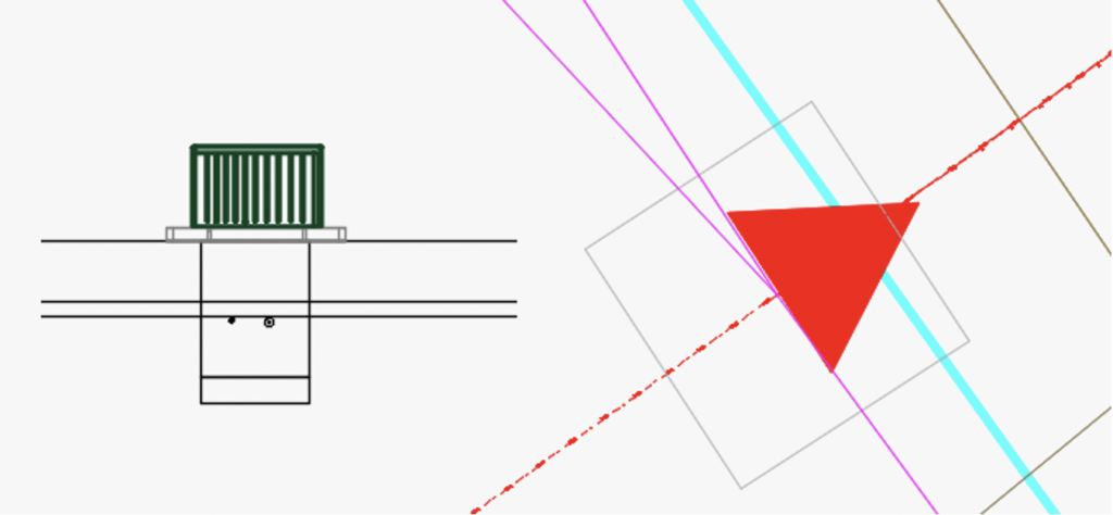
Traditional design of networked utility infrastructure has typically involved rather simple 2D layouts, referencing conductors, conduits, and associated paths between equipment and consumers. While this has served the industry for many years, building a well-defined digital twin during the design phase ensures not only a properly engineered system but also provides a framework for related business needs. A sample model is shown in the figure below.
While this model may appear to be quite abstract, it forms a basis for shielding an engineer or CAD designer from having to understand the details of the underlying digital components that turn points, lines, and areas into intelligent features that represent networked infrastructure. This provides a very powerful tool that allows a designer to build a digital twin without having to understand the complexities of network asset modeling.
What the designer sees is something quite different. This abstract model can be portrayed as a 2D layout that supports typical construction drawings. These drawings contain the necessary information to enable the construction process, including trench widths, offsets, fill, and depths.
Another advantage of intelligent, model-based design is the ability to model the 3D elements of the design in the background while performing a 2D layout using standard CAD tools. This enables essential design and engineering capabilities, such as clearance checking, constructability, safety, and compliance with standards, reducing the risk of construction-related issues when the design moves to the field. Bill of materials can also be generated much more accurately as lengths can be properly calculated based on having a 3D representation of the conduit path. The addition of 3D, digital-twin based models also provides for the benefit of highly visual design checks. A 3D view of the design above is shown in the connecting diagram.
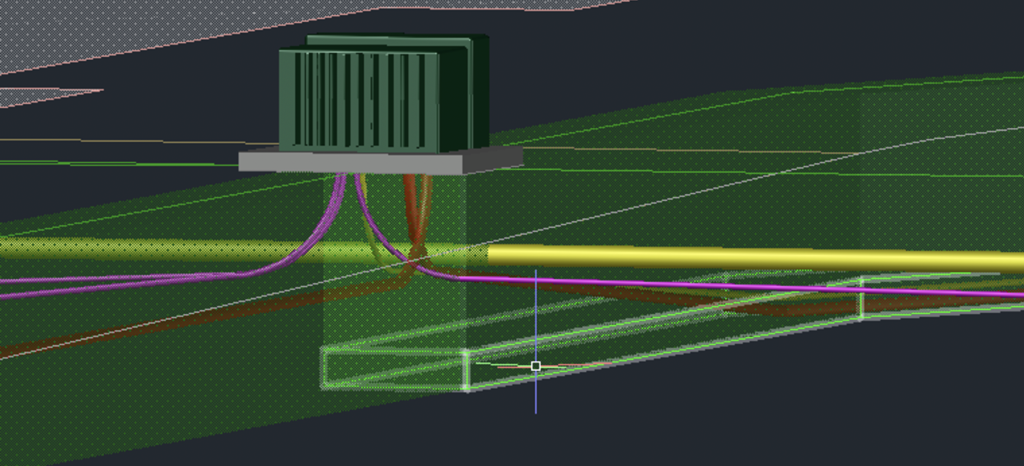
Here, another example is shown. In this case, the real-world model shows how the conductors pass through rotated vaults while including proper elevations and the necessary duct details.
GIS, CAD, and Conduit Management
While CAD-based intelligent design functions create models to support safe and effective construction of infrastructure assets, GIS plays a key role in data management, analysis, and lifecycle asset management of those same infrastructure assets. The design process often involves highly detailed representations of the planned infrastructure, usually over a fairly finite work location. On the other hand, the GIS manages a very large amount of assets, typically over a large geographic area. The same assets are represented in each system; however, their usage and purposes are distinctly different. For example, design typically requires highly accurate, real-world locations while conduit represented in GIS is often offset to ensure proper visualization on a two-dimensional map.
Examples of GIS-based conduit management activities include visualization of joint trenches, duct banks, and vaults and operations support for performing inspections and replacement activities. Planning and revenue related functions such as capacity planning, shared resource management, and replacement analysis are enabled by having well-defined conduit systems within the GIS. Similarly, fiber management functions for telecommunications rely on the GIS representations to manage visualization of fibers, cores, and cables and to provide a visual way of managing fiber splices.
What’s Next: Digital Twins and Next-Generation Networks
The business applications described above offer tremendous value for traditional utility and telecommunications assets. But the future of the electric grid is demanding a better way of managing advanced, dynamic networks. Distributed energy resources, the proliferation of sensors, advanced devices, and prosumers are driving the need to deliver advanced network models based on digital twins. It’s no longer practical to have large teams of manual data entry personnel editing different systems to support multiple network-based business applications.
Digital twins, based on intelligent design, integrated with GIS and other network-based systems provide the opportunity to enter data in one location and share it throughout the asset lifecycle without having to deal with redrawing, duplicate data entry, and the inevitable risks associated with out-of-date information.
If you have any questions, please contact SBS at [email protected]. We welcome the opportunity to share more details regarding the integration of intelligent design solutions and geographic information systems along with your digital twin and design integration requirements.
Substation Design Suite™ Protection & Control (SDS P&C) version 8.1 is now available. This new release includes over thirty product improvements designed to improve usability, electrical design efficiency, and quality.
SDS P&C extends the power of AutoCAD® Electrical to provide advanced electrical substation design capabilities necessary to fully layout and specify an electric substation. With the newest enhancements in version 8.1, you can now more efficiently produce quality substation protection and control designs. Here are six of our favorite updates:
Wild Card and Find/Replace Data Editor
Processes multiple instances of the same set of wild-carded “standard drawings” in an overall project drawing set.
Wiring Diagram Connection Count QA Check
Checks annotated wiring diagrams and creates a surfable list of terminal and device pin connections that have more than two wire connections on a single pin termination.
Cable Auto Fan-ins on Connection Wiring Diagrams
Does in one minute what might normally take hours or even days on intelligent terminal strip connection wiring diagrams.
Job/WO and Status Marking/Tracking/Reporting
Integrates job, work order, and status assignments into various reports and saves and restores client-specific sets of job and work order status names.
Ribbon User Interface
Makes several SDS-specific tools only a click away and adds some frequently used base AutoCAD Electrical tools.
Context -sensitive, comprehensive Help System
Covers new 8.1 capabilities.
If you’re interested in learning more about SDS P&C, please contact us at [email protected]. Click here to download the newest version.
Join Steve Kaufman of SBS to learn about exciting enhancements to SDS Physical for Inventor 8.0 such as support for multi conductors, ground leads to sloped planes, and Named User licensing.
Title: SDS Physical for Inventor 8.0 Release Webinar
Date: Tuesday, October 12, 2021, 12:00 – 1:00 PM EDT
Details:
Webinar will be held on GoToWebinar
Access the content on the Spatial Business Systems YouTube channel after the event.
We had many memorable moments at this year’s virtual conference. We thank each of our presenters for sharing their experiences and expertise. We wouldn’t be able to make this happen without you!
We extend a special thank you to our customers at Southern California Edison, Energy Queensland, Hydro One, Central Hudson, and Atwell LLC for presenting. Their organizations have been actively involved in transforming their businesses through modernizing their design workflows.
The conference started with Dennis Beck, President of SBS, providing an update on the latest happenings at the company. Reflecting over the five years since SBS acquired Autodesk’s line of utility design solutions, Beck noted that there have been over 500 product enhancements with a strong commitment to continue the company’s R&D efforts in the areas of digital twin support and enablement of advanced applications such as BIM and digital construction. He also announced that starting in November 2021, SDS Physical for AutoCAD (formerly AUD for Substations) will be generally available.Just to recap some of the highlights of the conference:
· Insightful training workshops. SBS customers shared best practices in training their user community and helping them adapt to intelligent design solutions.
· A presentation on the ability of Automated Utility Design™ (AUD) to track usage information to support business analytics. Attendees learned how this data can be used to improve overall business performance, ranging from design efficiency improvements to leveraging BIM and advanced asset management.
· The growing presence of SBS engineering firm customers. Attendees were able to learn how design firms are using AUD to support the utility design and construction ecosystem and collaboratively work with their utility customers to improve design quality and workflows.
· An SBS project delivery update. SBS actively manages about 40 projects at any given time, and a few of these projects were highlighted. This also included an update on SBS delivery methodologies and the recent improvements that have been made to streamline implementation.
· The latest updates on what SBS is doing with GIS integration, particularly with regard to Esri’s Utility Network. Dennis Beck and Andy Street also presented the SpatialBiz FME Plug-in for ArcGIS Utility Network, which is a new, streamlined way to migrate and/or synchronize information with Utility Network.
· Emphasis on mobile integration as part of our intelligent design solution workflows. Serguei Sokolov’s mobile solutions update showed the new work SBS has been doing to support as-built workflows to ensure they can be incorporated into GIS and other systems in a timelier manner.
Select presentations are available online for viewing. Please contact [email protected] if you would like to view some of these sessions.
This summer (July 2021) I had the good fortune of being able to deliver a Spotlight presentation for the Esri User Conference. My goal of the presentation was to take some of the hype out of digital twins (Trust me, there is a lot of hype.) and also to introduce the important concept of the digital thread, which is often overlooked in our critical infrastructure community. The presentation was well-received, and it was referenced in the VentureBeat (www.venturebeat.com) online publication. This blogpost summarizes the presentation and provides some additional details based on questions we have received here at SBS.
What is a Digital Twin?
In its simplest form, the digital twin is a digital model of a real-world object. Each twin represents a unique occurrence somewhere in the real world with the necessary sophistication to support relationships between objects and other elements within the system, including dynamic, sensor-based information. By its very definition, the digital twin is a non-static representation. It can grow over time, becoming more and more data rich based on construction information, asset history, and sensor-based data inputs. It can be thought of as a data container that becomes filled with more and more valuable information over its lifecycle. It is like a lean gymnast who grows into a sumo wrestler.
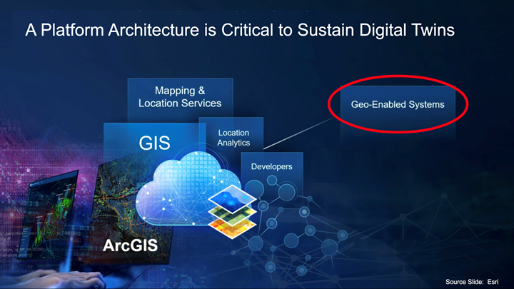
While digital twins have been getting a lot of hype over the last many years, it’s important to realize that the critical infrastructure GIS community has already been creating some form of digital twins for many years. They were initially known as “simple features,” but the technology has advanced to incorporate network modeling, federated data sources, sensor-based data (including Lidar),and advanced, geo-enabled applications. What was originally a very simple modeling construct has become a quite sophisticated, mature ability to model real-world assets.
In working with digital twins, it is critical to have the ability to rely on information from many different systems and to have an architectural platform that ties all this information together. GIS is consistently recognized as that platform. In particular, the ArcGIS platform is very rich in its ability to manage and integrate with other geo-enabled systems, supporting these applications with 2D and 3D representations, spatial and non-spatial relationships, network modeling, and many other powerful modeling constructs.
How About the Digital Thread?
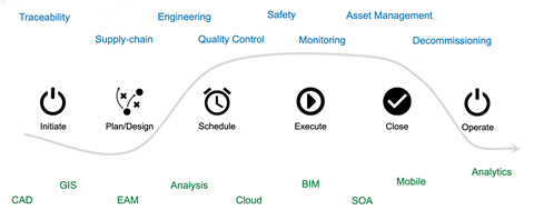
Now that we’ve defined the digital twin, let’s discuss the concept of the digital thread. Infrastructure design, build, and operation tends to follow a certain pattern: Initiate, Plan and Design, Schedule, Execute, Close, and Operate. Throughout this pattern, there are a number of business processes that typically happen throughout an asset’s life cycle. Here are some examples:
Material traceability
Engineering
Supply chain
Management and maintainability
Decommissioning
And more
That means an asset touches many different systems (CAD, GIS, engineering analysis tools, etc.), and that list of systems is not getting any smaller. The path that the asset or digital twin travels through these systems is what we refer to as the digital thread, which can begin at or before the inception of the asset all the way through its operation and decommissioning.
Challenges to Implementing Digital Twins and the Digital Thread
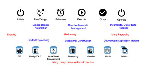
The digital thread and its associated digital twin have the potential to generate a tremendous amount of value in the design, construction, and operation of critical infrastructure, but historically, there have been a lot of challenges that have prevented us from implementing this vision. Here are some of the key issues:
There are a significant number of systems that need to be accessed, which adds extensive complexity to a properly implemented digital system. This is manifested in different ways, but one challenge we’ve seen over the years and decades is extensive data re-entry.
Looking more specifically at graphical information, organizations will design something initially in a CAD system and then they will then redraw it in a GIS to create a system of record. The redrawing doesn’t end there as a different graphic representation of the data may be required to support specialty applications such as network management systems. This extensive re-entry of complex, graphical information results in complex data duplication issues.
The actual engineering of the planned infrastructure systems tends to get short-changed due to the complexity of moving data between the designs and the specialized engineering tools necessary to perform a detailed engineering analysis. This creates suboptimal designs.
This limited automation and lack of detailed information can impact the material accuracy. As a result, the supply chain and materials management become reactive as opposed to proactive, which then impacts the success of the field construction. This is where it can get very costly for infrastructure owners and operators.
No matter how well you digitize all your designs and information going out to the field, if it’s printed out and put in a folder, that creates a big information gap with out of date records during construction and as-built documentation.
Ultimately, the casualties of this bad information flow tend to be those downstream applications that rely on very current information to perform advanced business functions that should be taking advantage of robust digital twins.
How to Overcome the Challenges
There are many things that can be done to make your digital twin and your digital thread implementations a reality in spite of the challenges identified above.
The first step is to think architecturally as you implement your information systems, keeping your end goals in mind.
Use an intelligent design system. Since the design process is where the asset information is created, it is important to use an intelligent design system to create the well-defined objects that form the digital twins. Some organizations take shortcuts during the design process via the use of simple drawings or even just sketches. Instead, a well-conceived approach to building intelligent models will enable geo-location, materials management, network topology, and the other elements necessary to build, operate, and maintain critical infrastructure.
Be spatially aware throughout the entire process. All critical infrastructure is dependent on location, and this has a significant impact throughout the asset lifecycle from construction through operations and decommissioning. Proper spatial enablement opens opportunities to incorporate less-commonly used datasets for soils, weather, vegetation, and other emerging sources of data that can be used to make advanced asset management decisions.
Don’t lose track of the data. A properly architected system will be structured in such a manner that data is not only retained but made available in a usable form to support lifecycle business applications, many of which have not yet been identified.
Keep security front and center. As we architect systems to make the data more and more available for advanced applications, we also have to realize that it has the potential to create vulnerabilities that can be exploited by bad actors.
The second step is to address the fact that there are many different personas that will be relying on the digital twins. Consider an electric pole: a designer needs to have detailed information about attachment heights, connections, angles, and more to determine the proper structural characteristics. A manufacturer needs the base material information, specifications, and usage conditions. A builder needs to know not only the detailed plans but also the detailed real-world location. That real-world location is not nearly as critical for the maintainer; instead, the maintainer needs to know how to access the asset and how to not violate any right of way concerns or environmental restrictions. Furthermore, the operator may not care where the pole is but must see the operational picture of the network environment. Finally, the asset manager needs to understand the financial profile, the reliability history, and all those events that contribute to aging and key decisions in optimizing the asset life cycle. Each of these different personas has unique needs that must be thoroughly considered.
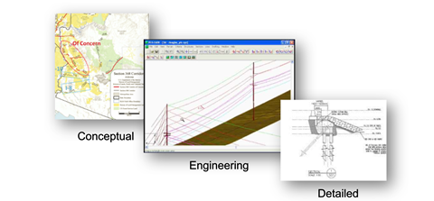
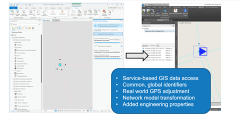
The final step is to focus on the necessary data transformation to make information usable to different consumers. This is an area where SBS has been doing extensive work to support the business requirements of the different digital twin consumers and representations. The example below shows electric transmission system assets from conceptual to engineering to detailed design. All three representations reference the same system, but it has to be transformed for the different consumers.
Current Examples
This section shows some examples of our efforts at SBS in using digital twins and digital threads to solve infrastructure management challenges. We refer you to our Esri User Conference Spotlight presentation for more details. In the presentation, you will see the following:
Design integration with CAD and GIS
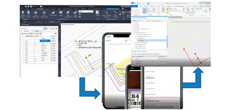
As-built integration with CAD, mobile computing, and GIS
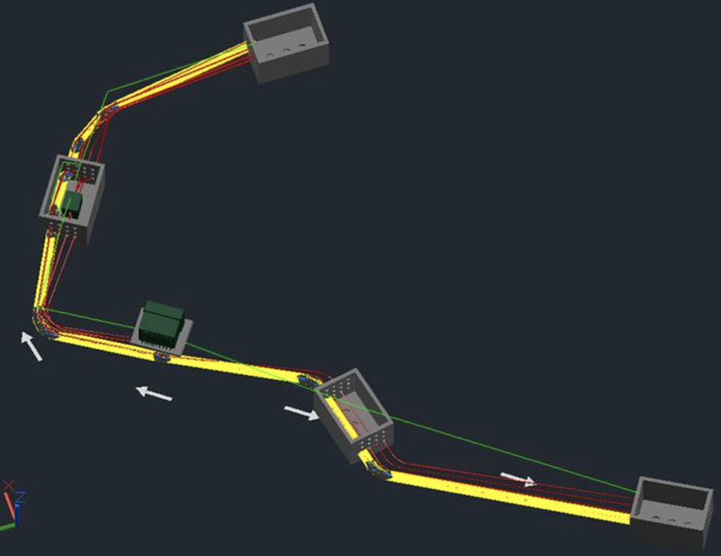
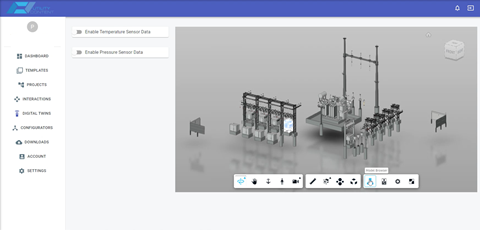
Integration of 3D intelligent design models with operational digital twins in an electric substation
Conclusion
Digital twins are a very powerful construct, but to take advantage of them requires a change in how we think about managing infrastructure information. Part of that thinking needs to flow into the digital thread, which expands the digital twins to be part of an integrated asset life cycle.
A well-conceived, geo-enabled architecture generates very significant benefits. The design process becomes much more efficient when using intelligent models to build twins. Data re-entry is reduced quite extensively, which can provide more current information to support advanced applications. This opens the door to other exciting things such as optimization of asset performance and the ability to generate analyses that we haven’t been able to do before.
If you have any questions, please contact SBS at [email protected]. We are happy to help you with your digital twin and design integration requirements for critical, networked infrastructure.