New Version Improves Performance, Adds Smart Trace and Supports Esri Utility Network Model
Automated Utility Design™ Version 8.0 (AUD) is now available! AUD 8.0 is the biggest release to–date from SBS and adds several significant enhancements to the product. Most notable are the extended capabilities to support integration with Esri’s ArcGIS Pro and the new Utility Network (UN) Management extension which was announced during our January 2019 blog post. While these new features were designed to support Esri Utility Network, the capabilities will improve data exchange between most advanced GIS systems including G/Tech and Smallworld. While the previous post highlighted AUD’s advanced modeling capabilities and improved editing features, this post will focus on some of the key new AUD capabilities.
Improved Performance
A continual objective of SBS is to improve overall user experience and product performance. AUD 8.0 continues that standard.
As utilities are putting more assets underground, SBS teamed with our customers to investigate how to improve performance for complex underground design scenarios. The results of this analysis led to a 15% or greater increase in performance for underground design. Examples of enhancements include faster editing of conduit positioning in the trench layout, 3D visualizations for the trench and a 2D cross-section of the trench.
Additional changes in AUD 8.0 resulted in a 25% decrease in the time required to open larger drawings as well as dramatic improvements to responsiveness when selecting and editing with AUD Info tools on larger, complex designs.
Additionally, improvements have been made to support Customer’s that have very large material catalogs. While most customers will see a slight improvement in performance, a comparative test of one customer with a very large catalog showed a nearly 5-fold performance improvement.
Improved User Interaction
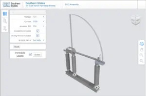
AUD 8.0 expanded trace capability, combined with the Utility DataHub’s ability to remotely invoke GIS transactions, provides the Designer a with a more complete system–level design and analysis solution. Previous versions of AUD provided basic highlighting to show what features had connectivity in the design. AUD 8.0 now provides configurable trace definitions to select parts of the network. Working in tandem with the new AUD Table functionality, an AUD user can now perform traces that will automate routine counts and calculations of features in a design.
Prior to AUD 8.0, tracing was limited to highlighting the features that had connectivity. Although the connectivity tracing capability is extremely useful for design integrity to ensure connectivity of features, it was limited in the ability to support system level design integrity and analysis.
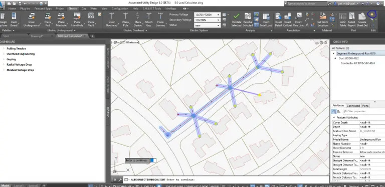
AUD showing Connectivity
Through simple configuration of AUD options, enhanced tracing can be added to an AUD template. In the sample below, an intelligent trace was created to read the load of each new service point designed along this circuit. The results are displayed in a table showing each individual service point’s load, as well as the total load being added. To simplify this common search, the analysis pallet was configured with a new button to initiate the trace on command.
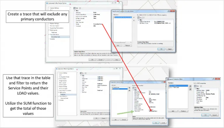
The new trace capability, combined with the power of the SBS Utility DataHub™ Design-GIS module’s ability to interact with the GIS, advances the integration of CAD based engineering design with GIS spatial analysis.
Better Data Exchange
SBS has been working collaboratively with our user community to further improve CAD mapping and conversion workflows for external parties that need to share data with AUD. A new command can be used to easily perform bulk conversion of non-AUD CAD drawing objects. The conversion is based on matching AUD Styles as well as optional new value mappings in the Style definitions. These enhancements are particularly helpful for utility organizations that need to receive traditional CAD data from Applicant Designers or third-party engineering firms.
The better exchange of data reduces the need for 3rd party conversion tools, manual redrawing and data clean-up while simplifying the overall workflow. It also allows utility organizations to have more current and accurate data available for their GIS and critical downstream systems such as engineering analysis, outage management, advanced distribution management systems.
*****
AUD 8.0 continues the SBS tradition of working collaboratively with our user community to advance the state-of-the-art in utility design solutions. We particularly appreciate the customers in our SBS Peer Utility Group that contributed their ideas on how to improve AUD. We welcome future feedback from all AUD users and encourage you to join the Peer Utility Group as a forum to share your thoughts and ideas.
For additional information on Automated Utility Design please contact Stefen Dobrec, [email protected].